Planning

Our expertise spans travel demand modeling, corridor and route studies, feasibility assessments, and long-range planning for state, MPO, and community projects—in turn enhancing mobility to promote inclusion, equity, and economic vitality. We integrate environmental planning and emerging technologies with data-driven analysis to deliver innovative, cost-effective solutions to help future-proof transportation systems throughout our communities.
Additionally, we can design the following:
• Travel Demand modeling
• Environmental Planning
• Emerging Technologies
• Corridor, feasibility and route assessments
• Long-range planning for State, MPO and
• Community projects
Unified Transportation Program (UTP) 2.0
State of Texas
OTHON supports TxDOT’s Unified Transportation Program (UTP 2.0), providing technical analysis and planning services to guide statewide transportation investments. Our team delivers data validation, funding alignment, GIS support, and crash and bridge analysis to help TxDOT prioritize projects across all modes.
By streamlining planning and programming, OTHON enhances transparency, consistency, and responsiveness—connecting communities and strengthening mobility across Texas.
By streamlining planning and programming, OTHON enhances transparency, consistency, and responsiveness—connecting communities and strengthening mobility across Texas.
Statewide Multimodal Transit Plan (SMTP)
State of Texas
OTHON partnered with TxDOT to develop Texas’s first Statewide Multimodal Transit Plan—a groundbreaking initiative that establishes a comprehensive framework for evaluating and advancing multimodal transportation solutions across the state. The plan assessed current infrastructure and future needs across roadways, transit, bicycle and pedestrian networks, and freight/rail corridors.
As a key contributor, OTHON led multimodal corridor prioritization, regional system evaluations, and emerging technology assessments. We also supported travel demand modeling and designed inclusive public outreach strategies to engage communities statewide. Our work helped shape actionable implementation tools that position Texas to enhance mobility, support growth, and ensure resilient, equitable access for all.
As a key contributor, OTHON led multimodal corridor prioritization, regional system evaluations, and emerging technology assessments. We also supported travel demand modeling and designed inclusive public outreach strategies to engage communities statewide. Our work helped shape actionable implementation tools that position Texas to enhance mobility, support growth, and ensure resilient, equitable access for all.
I-35 Austin-San Antonio Linking Study
Hays County & Comal County, Texas
Project Distance
41mi
OTHON conducted a comprehensive feasibility study for TxDOT to evaluate adding two managed lanes in each direction along a 41-mile stretch of I-35, connecting the future CapEx South in Austin with the NEX project in San Antonio. This corridor—one of the most congested and heavily traveled in Texas—plays a critical role in regional mobility.
Our team performed traffic engineering and modeling to assess managed lane alternatives, including demand forecasting, operational analysis, and integration with CAMPO and AAMPO regional travel demand models. OTHON also led data validation, scenario development, and technical coordination with multiple stakeholders to ensure consistent assumptions and reliable forecasts.
By bridging two major metropolitan managed lane systems, the study advances a unified, regional approach to mobility in Central Texas—supporting long-term congestion relief, improved travel reliability for commuters and freight, and enhanced connectivity across the region.
McCart Avenue Corridor Study
Fort Worth, Texas
Project Distance
3.5mi
OTHON is leading traffic analysis and planning for the McCart Avenue and Altamesa Boulevard corridors in Fort Worth, focusing on current and future mobility, safety, and multimodal connectivity. Using traffic volume data, INRIX speed analytics, and crash records from TxDOT’s CRIS database, our team developed a TransModeler micro-simulation to evaluate delays, levels of service, and long-term operational challenges.
The study identified key bottlenecks, high-crash zones, and pedestrian access gaps, providing the City of Fort Worth with data-driven recommendations for signal optimization, safety enhancements, and multimodal improvements. By modeling future growth scenarios, OTHON is helping the City build a resilient strategy for long-term corridor management and mobility planning.
The study identified key bottlenecks, high-crash zones, and pedestrian access gaps, providing the City of Fort Worth with data-driven recommendations for signal optimization, safety enhancements, and multimodal improvements. By modeling future growth scenarios, OTHON is helping the City build a resilient strategy for long-term corridor management and mobility planning.
US 287 Corridor Development Study
State of Texas
Project Distance
754mi
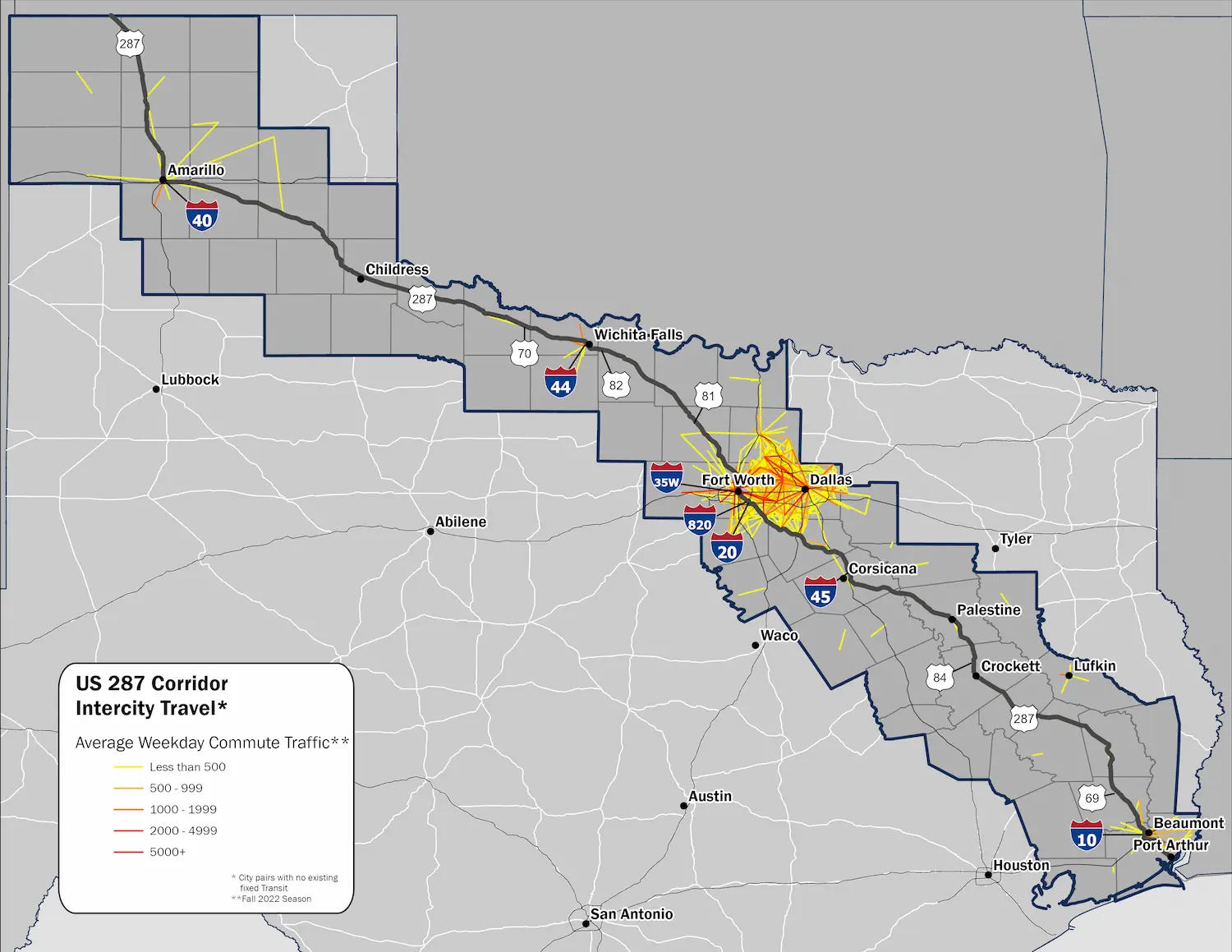
OTHON completed a comprehensive feasibility study of the 754-mile US 287 corridor, spanning 43 counties and nine TxDOT districts from Port Arthur to the Texas/Oklahoma state line. The study focused on evaluating multimodal needs—including freight, transit, and bicycle/pedestrian access—along one of Texas’s most critical freight and mobility corridors.
Our team developed strategic solutions to improve safety, connectivity, and efficiency, aligning recommendations with TxDOT’s Unified Transportation Program. Using advanced R and Python techniques, OTHON processed over 18 million trip records to generate GIS-ready outputs and city-pair origin-destination mapping. We conducted detailed crash analyses, including correlations between roadway geometry and CMV incidents, and worked closely with stakeholders to define evaluation criteria and identify targeted countermeasures.
By integrating freight priorities, safety data, and future resiliency needs, the study equips TxDOT with actionable strategies to enhance corridor performance and support long-term economic growth across the state.


